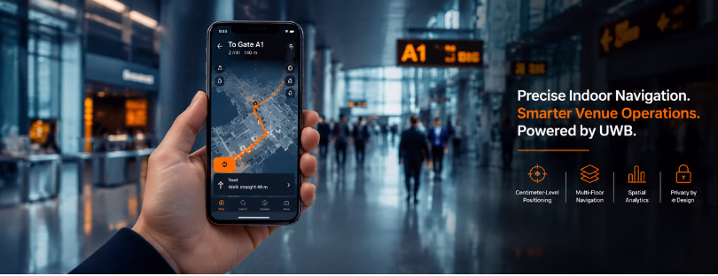
UWB Indoor Navigation Turns Phones Into Venue Guides
Eforthink has announced its UWB Indoor Navigation and Spatial Services Solution, a platform designed to bring centimeter-level indoor positioning to UWB-enabled smartphones in large venues such as airports, shopping malls, hospitals, exhibition centers, museums and stadiums.
That sounds technical, but the idea is simple: your phone should know where you are indoors with the same confidence it has outdoors. Not roughly. Not “somewhere near Gate B12.” Precise enough to guide you from a car park to a store entrance, from a hospital lobby to the right clinic, or from a museum entrance to a specific gallery without the familiar blue-dot wobble.
The bigger point is that Eforthink is trying to remove the awkward hardware layer that has slowed many indoor navigation projects. Instead of asking visitors to carry dedicated tags, rent devices or depend on patchy Wi-Fi, the system turns compatible smartphones into positioning devices.
Why UWB matters
Indoor navigation has always had a strange problem. Everyone understands the need for it, but the experience often feels unfinished. GPS struggles indoors. Wi-Fi and Bluetooth-based systems can work, especially for broad wayfinding and analytics, but precision, latency and reliability vary heavily by venue layout and signal conditions.
Ultra-wideband, or UWB, is different because it was built for precise ranging. In practical terms, it can support much finer positioning than most signal-strength approaches. That matters in places where “near enough” is not good enough: hospitals, underground parking areas, transit hubs, retail, sports venues and crowded public buildings.
Eforthink’s solution is built on a downlink UWB DL-TDoA architecture, meaning Downlink Time Difference of Arrival. In this model, UWB anchors broadcast signals and the smartphone calculates its own position locally. It supports high-density environments because many people can receive signals without each phone constantly transmitting back to the infrastructure. It also gives the privacy story more weight, because the user’s location can be calculated on the device rather than exposed to the venue.

More than wayfinding
The most interesting part of Eforthink’s announcement is not the map. It is the operational layer around the map.
The company says the system combines UWB anchors, spatial maps and navigation algorithms to support real-time positioning, arrival detection, multi-floor route planning and spatial analytics. For a visitor, that means a cleaner journey through a complex building. For the venue operator, it means something more strategic: understanding how people move, where they stop, where congestion builds and which points of interest are being found or missed.
READ MORE: BMW introduces UWB digital car keys for Android devices
That is where indoor positioning becomes less of a convenience feature and more of a venue intelligence tool. In a mall, it could connect parking, store navigation and dwell-time analysis. In an airport, it could support passenger flow and gate-to-service routing. In a hospital, it could reduce stress for patients and visitors navigating a high-pressure environment.
Eforthink is also making the system available through SDKs and APIs, which is the right move. Indoor navigation will not become mainstream if it lives as yet another standalone app. It needs to sit inside venue apps, ticketing tools, parking systems, loyalty platforms and smart building software.
The competitive picture
Eforthink is entering a market that already has several approaches. Pointr has built visibility around indoor blue-dot navigation. Situm works across Wi-Fi, BLE, GPS and smartphone sensors. Mapsted promotes a hardware-free indoor positioning model. Comarch, often seen in the UWB ecosystem, is more associated with FiRa test tools, interoperability and asset-tracking implementations than with consumer-facing venue navigation.
That variety matters because indoor positioning is not a one-size-fits-all market. A small museum may not need centimeter-level UWB. A hotel may prefer a lighter solution based on existing infrastructure. A retailer may choose BLE or Wi-Fi if the goal is broad analytics rather than exact turn-by-turn guidance. UWB becomes more compelling when precision, privacy, density and real-time performance are central to the business case.
READ MORE: Xiaomi introduces UWB on Mi 10 series
The market direction is clearly moving toward more intelligent indoor spaces. Fortune Business Insights expects the indoor positioning and navigation market to grow sharply through 2034, while FiRa Consortium has been pushing UWB-based untracked indoor navigation, especially through DL-TDoA, as a way to improve accuracy, scalability and privacy.
What still needs proving
The announcement is promising, but the real test will happen in messy buildings, not press releases. UWB performance depends on anchor planning, venue geometry, device compatibility, map quality and integration with real customer journeys. Airports, hospitals and malls are full of corners, elevators, reflective materials and changing layouts. A solution can be technically impressive and still fail if the app experience feels confusing or if the venue does not keep maps updated.
There is also a practical adoption question. UWB-enabled smartphones are increasingly common at the premium end of the market, but not universal. Venues serving broad public audiences will need fallbacks for visitors with older devices.
The real signal
Eforthink’s launch points to a bigger shift: indoor navigation is becoming part of the smart venue stack, not a novelty feature. The winners will not simply be the companies promising the most accurate blue dot. They will be the ones that make indoor location useful, private, interoperable and easy to embed into the services people already use.
Compared with BLE, Wi-Fi or hardware-free approaches, UWB will not be the cheapest route for every venue. But for complex spaces, it has a strong case. Eforthink’s opportunity is to prove that smartphone-based UWB can move from an impressive demo to everyday infrastructure.