AR Navigation for Tourists: Point Your Phone, Get Instant Info
Imagine this: You’re standing in a foreign city, trying to figure out where that famous cathedral is or which alley has the best local eats. You pull out your phone, point it at the street ahead, and bam—your screen lights up with live directions, restaurant reviews, and even historical trivia floating right over real-world buildings. AR Navigation for Tourists
Welcome to the era of AR (augmented reality) navigation, where maps meet magic.
What Is AR Navigation Anyway?
Let’s break it down real quick. AR (augmented reality) isn’t VR. You’re not diving into a fully digital world. Instead, AR layers digital content—like images, text, or 3D models—over the real world using your phone’s camera or AR glasses.
So, instead of staring at a flat map or following a blue dot, AR navigation lets you see arrows and guides right on your screen, overlaid on the sidewalk or road in front of you. You’re literally walking through your directions.
And for travelers? This is huge.
Why Travelers Are Loving It
- No more “Which way is this map pointing?” confusion
You know the struggle. You open Google Maps, turn left, only to find out you’ve walked two blocks the wrong way. AR navigation ends that. Apps like Google Live View or Apple’s AR walking directions use your camera to orient you instantly, then guide you in real time—on-screen, on the street. - Instant context
Let’s say you’re in Rome, pointing your phone at a random old building. With AR, instead of Googling “What’s that dome thing near the Tiber?”, your phone tells you instantly, “That’s Castel Sant’Angelo, built in the 2nd century.” Some apps even show you how it looked 1000 years ago. Wild. - Language barriers? Handled.
Many AR travel apps now translate signs, menus, and notices on the fly. Just point your camera, and boom—it switches from Japanese to English (or whatever you need). You’re no longer guessing what you just ordered or where that bus is headed. - It’s more immersive and fun
Let’s be honest: getting directions from a floating arrow on your camera is just… cool. It’s like playing a game, except it’s your real life—and it gets you to the nearest gelato.

Real-World Examples That Are Already Here
This isn’t sci-fi stuff anymore. It’s happening now.
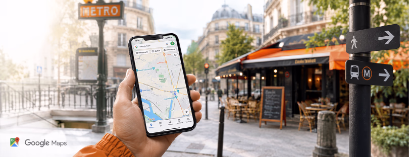
- Google Live View: Maybe the most well-known, this uses AR for walking directions in cities. You point your phone up, and arrows appear on the screen, showing you which way to go. It even recognizes landmarks.
- Apple Maps (Look Around & AR directions): iPhones now offer AR walking directions in selected cities. It’s super clean and feels native to iOS.
- BlippAR & Wikitude: These two are geared more toward cultural experiences. Point your phone at a monument or artwork, and get facts, stories, and background instantly.
- TimeLooper: AR but make it historical. In certain places, it lets you “time travel” by showing 3D recreations of what historical sites looked like in their prime.
- Lens (Google/Pixel): While not strictly AR navigation, it’s magic for travelers. You point it at menus, signs, landmarks—and it reads, translates, and explains.


The Cool Stuff Coming Next
Alright, so where’s this headed?
➡️ AR Glasses: Yep, like actual glasses. No more holding up your phone like a tourist beacon. You’ll wear glasses that quietly guide you, overlaying directions, translations, and info in your field of view. Think Ray-Ban Meta or Apple Vision Pro (when it gets lighter and less mortgage-y).
➡️ Hyper-personalized AR guides: Imagine your phone knows your interests (architecture, coffee, street art), and as you wander, it highlights stuff you’ll actually care about—with reviews, recommendations, or even discount alerts.
➡️ Gamified city tours: Like Pokémon Go meets cultural tourism. Follow clues, scan buildings, and unlock stories. It’s already in motion with apps doing AR scavenger hunts.
➡️ Offline AR content: We all know roaming can be expensive (unless you’re using an eSIM from Alertify, just saying 😉). Soon, AR apps will let you download entire cities—maps, POIs, translations—so you can get the experience even without a data connection.

A Few Downsides (Let’s Keep It Real)
No tech is perfect, right?
🔋 Battery killer: Using your camera + GPS + data = fast battery drain. Keep a power bank handy.
📶 Needs a good connection: Some AR features lag if you’re on slow data. Another reason why a fast local SIM or eSIM makes a difference.
🌐 Not available everywhere (yet): Most AR navigation works best in major cities. Rural towns or lesser-known places? Still catching up.
👀 People will stare: Holding your phone up in the middle of the street still looks odd in some places. Own it.
Should You Try It?
100%. If you’re the type of traveler who likes exploring cities on foot, discovering hidden gems, and not feeling glued to a map—you’ll love AR navigation.
Whether you’re navigating a maze of backstreets in Lisbon or trying to figure out which train to take in Tokyo, AR takes a lot of the stress (and guesswork) out of the equation. It’s especially helpful for solo travelers or first-timers in a city.
And as the tech matures? We’re heading toward a world where you’ll be able to explore any destination like a local—with just your phone or glasses as your guide.
Final Thoughts About AR Navigation for Tourists
Travel has always been about discovery, but let’s be real—it’s also about not getting totally lost, missing your reservation, or accidentally ordering cow tongue.
AR navigation is quietly becoming the go-to companion for modern travelers, blending information with intuition in ways that traditional maps just can’t match.
So next time you’re packing for a trip, maybe skip printing out directions and instead make sure your AR apps are updated. Because the best way to explore? It might just be right in front of you—all you need to do is point your phone.